 |
|
UC Today is the quarterly newsletter of the Bureau of Reclamation’s Upper Colorado Basin Region covering the states of Colorado, New Mexico, Utah and Wyoming. We look forward to sharing with you some of the projects and activities that we have been working on to manage, develop and protect water and related resources in an environmentally and economically sound manner in the interest of the American public. Fall 2022 |
||||||
| Upper Colorado Basin Region Office | Albuquerque Area Office Power Office | Provo Area Office |Western Colorado Area Office | Four Corners Construction Office |
||||||
|
from the |
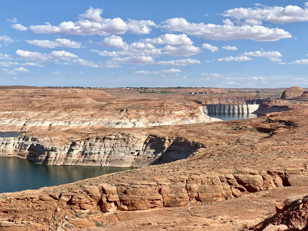 |
| Glen Canyon Dam and Lake Powell. Reclamation photo |
Reclamation proposing alternatives to near-term operations of Glen Canyon and Hoover dams
|
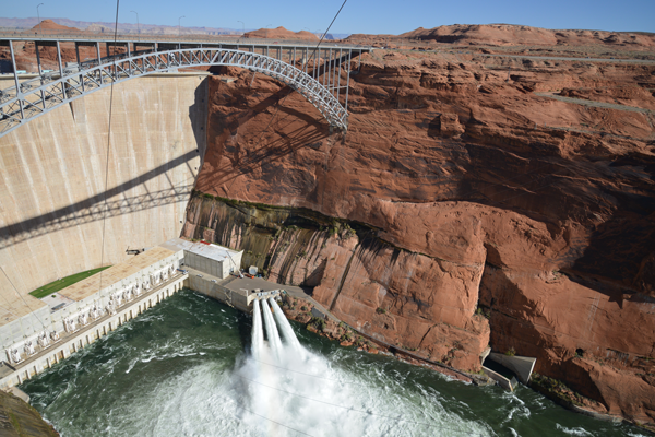 |
| Photo of November 2016 High Flow Experiment at Glen Canyon Dam. Reclamation photo by Amee Andreason |
No High Flow Experiment at Glen Canyon Dam this fallBy Upper Colorado Basin Public AffairsIn August 2022, it was determined there is sufficient sediment in the Colorado River to trigger a fall High-Flow Experiment. As described in the Long-Term Experimental and Management Plan Record of Decision, HFEs are experimental in nature and are designed to achieve a better understanding of whether, how, and when to incorporate high flow releases into future dam operations in a manner that maintains or improves beaches, sandbars, and associated habitat. Under the LTEMP ROD, the Department of the Interior may conduct flow-based experiments (HFEs, Bug Flows, Trout Management Flows, and Low Summer Flows) at Glen Canyon Dam when resource conditions warrant and if it is determined that there will not be unacceptable adverse impacts on other resources. After careful assessment of resources and best available science, by consensus, it was determined that a 2022 fall High-Flow Experiment at Glen Canyon Dam of any duration (24-hour to 192-hour) will not be implemented. The risk for potential impacts to a wide range of resources was deemed significant. These impacts include:
Water Year 2022 was the fifth full year of implementing the process for annual experimental planning under the LTEMP ROD. The last High-Flow Experiment conducted by the Department of the Interior occurred during Nov. 5-8, 2018. The HFE release included a peak flow of approximately 38,100 cubic feet per second for 60 hours (four days including ramping from baseflows to peak release) to move accumulated sediment downstream to help rebuild beaches and sandbars. This HFE release was the first to be conducted under the 2016 LTEMP HFE Protocol. Similar HFE releases were conducted in 2012, 2013, 2014 and 2016 in accordance with the 2011 HFE Environmental Assessment Protocol. The 2018 HFE release provided resource benefits and scientific information to be used in future decision making. For future experimental planning, the Department welcomes input from each the Leadership Team members as to whether the current process or another process should be used to satisfy the coordination and communication requirements under the LTEMP ROD. |
|
from the |
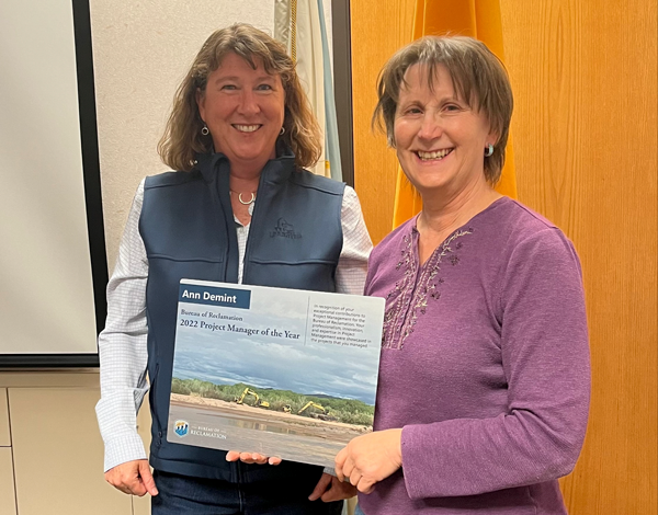 |
| Following a virtual ceremony, Albuquerque Area Manager Jennifer Faler presented Ann Demint with the Reclamation Project Manager of the Year award. Reclamation photo |
Alburquerque Area Office Engineer Ann Demint wins Reclamation Project Manager of the YearBy Upper Colorado Basin Public AffairsLast week, the Bureau of Reclamation recognized Upper Colorado Basin Civil Engineer Ann Demint from the Alburquerque Area Office as Reclamation's Project Manager of the Year at a virtual ceremony. The award reinforces the importance of project management for Reclamation's mission of delivering water and electricity to the Western United States.
Reclamation is honoring Ann for her management of projects within the Upper Colorado Basin Region in support of the Middle Rio Grande River Maintenance Program. Ann began her career with the Albuquerque Area Office in 2012 and is currently assigned highly complex projects supporting water management in the West. She is known by colleagues as a knowledgeable mentor, a strong leader and for working collaboratively with stakeholders to ensure project success. Ann is the project manager for a large number of river maintenance projects and activities, which are part of the Middle Rio Grande Project in New Mexico. In addition to managing individual projects (many of which are highly technical and complex), Ann coordinates the entire MRG River Maintenance Program, and all construction work performed by the Socorro Field Division. The program provides for effective water and sediment transport and protection of riverside facilities along more than 250 miles of the Rio Grande in New Mexico with an annual budget of over $10 million.
This year, Ann has developed charters, established teams, and ensured tracking for multiple river maintenance projects including, but not limited to, Sandia RM 202.2 Phase II, Santa Ana RM 205.8, Corrales RM 199, Los Lunas RM 163, and Truth or Consequences Channel maintenance. Each of these projects has complex and unique set of physical, environmental, and political circumstances that requires understanding of the policies and procedures that are vital components of project success. The teams she has established and led include a broad range of technical specialists such as engineers, construction experts, and environmental subject matter experts. Reclamation's award announcement coincided with International Project Management Day Nov. 3, a designated occasion to encourage project-based organizations like Reclamation to demonstrate appreciation for the achievements of project managers and their teams. Reclamation also recognized four other nominees for the Project Manager of the Year Award. They are:
Be sure to congratulate Ann on her award the next time you see her! |
|
from the |
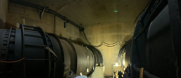 |
| This picture of two river outlet works (ROW) at Glen Canyon Dam was taken before work started to create a new, lower water intake for the city of Page, Arizona. New piping will lead from the large ROW pipes to a smaller 12-inch pipe (pictured top left running along the ceiling) that already conveys raw water from Lake Powell to Page's water treatment plant. Reclamation photo |
Glen Canyon Field Division begins work to ensure water delivery to the city of Page and the Navajo NationBy Lori HeibultThe city of Page, Arizona, was established in 1957 for workers who were constructing Glen Canyon Dam. Through a 1975 agreement, the dam still delivers raw water from Lake Powell to the Page's municipal water system which, in turn, delivers water to area residents, including the neighboring LeChee Chapter of the Navajo Nation. This water delivery system currently draws in water from Lake Powell from two intakes: 1) the main intake at a reservoir elevation of 3,480 feet, and 2) from taps into the penstocks on generator units 7 and 8 in the Glen Canyon Powerplant at elevation 3,462 feet. Because of Lake Powell's historically low water levels due to persisting drought and low run-off conditions, there was growing concern that the lake's elevation could drop below the second intake, threatening the water supply for the nearly 7,500 residents and more than 2 million tourists that visit each year. 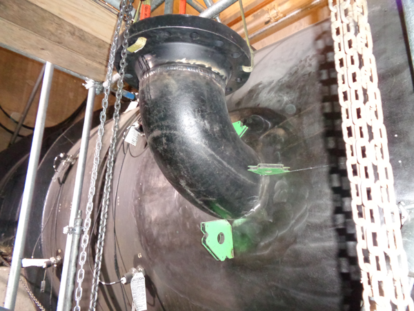 "We initially realized the potential need to modify the delivery process as the 24 Month Studies revealed the potential drop in elevation below 3,490 feet by June 2023," said Deputy Power Manager Bob Martin. "Our engineers with our crews looked at a number of possible options and we are pleased that we were able to come up with a relatively easy solution to a potentially large problem for people who rely on this water source." The endeavor to intake water from a lower elevation will be accomplished through an extension of the original water agreement with the city of Page. The city provided staff at Glen Canyon Dam with supplies and will pay for the labor to connect the water supply line to the river outlet works, approximately 100 feet lower than the penstock intake elevation. 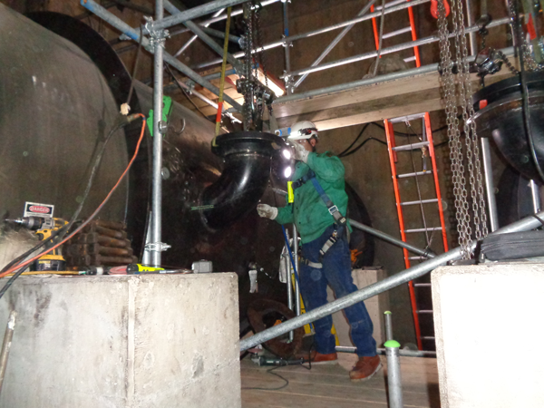 This operations and maintenance work will be accomplished by the installation of a fabricated manifold that will connect two outlet works pipes to the current 12-inch header pipe that delivers raw water to the city. Glen Canyon personnel began work in October and should have the work completed in December (the timeline accounts for a 2–3-week hiatus to accommodate other planned O&M work). Lake Powell's current elevation is 3,529 feet – down approximately 16 feet from this same time last year – and will continue to decrease until the 2023 spring runoff starts. "Reclamation is committed to the collaboration with the city to ensure water for the residents and visitors of the area," said Martin. "We live and work here in the community too, and we will continue to be good neighbors and stewards of this most important resource." 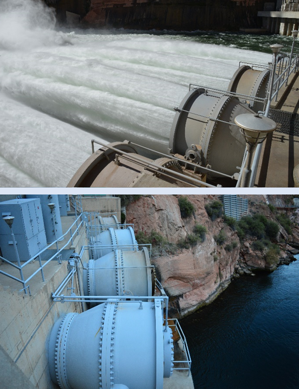 |
|
from the |
 |
| Workers on the Steinaker Service Canal Pipeline Project site trim and clean the facing surfaces on two sections of 84-inch-diameter HDPE pipe in preparation for fusing by a fusing machine. The project in eastern Utah will replace nearly 3 miles of open canal with the enclosed, high-pressure pipeline. Reclamation photo by Chris Watt |
Piping the Steinaker Service CanalBy Chris Watt, Upper Colorado Basin Public AffairsThe pipe dreams of the Steinaker Service Canal in eastern Utah are finally coming true. When irrigation systems were originally set up in the West, open canals were the best way to move water using the limited resources available at the time. As technology and access to resources has improved, more and more open service canals are being replaced with high-pressure, enclosed pipelines. Since construction was completed in 1961, the Steinaker Service Canal has delivered water from Steinaker Reservoir to project lands in Ashley Valley, in northeastern Utah. According to Supervisory Civil Engineer of the Provo Area Office Field Engineering Division Spencer Strand, "The Uintah Water Conservancy District is enclosing the Steinaker Service Canal in order to reduce water losses due to seepage into canal banks and to improve operations by automating the pipeline." Running approximately 12 miles from Steinaker Dam, the service canal loses approximately 5,000 acre feet of water every year, accounting for about 25% of releases from the reservoir. In the early 2010's, the Uintah Water Conservancy District undertook a study to improve the efficiency of the Service Canal, eventually deciding to enclose the existing open canal in a pressurized pipe. In addition to eliminating seepage losses, the pipe would improve efficiencies by providing automated deliveries of pressurized irrigation water to end users. Due to funding limitations, the district decided to construct the pipeline in phases, or reaches, beginning at the end of the canal farthest from the dam. Reach 1 was constructed in 2017 and 2018, comprising the installation of approximately three miles of pipe. The construction contract for Reaches 2 and 3A (comprising another three miles of pipe) was awarded in June 2022. 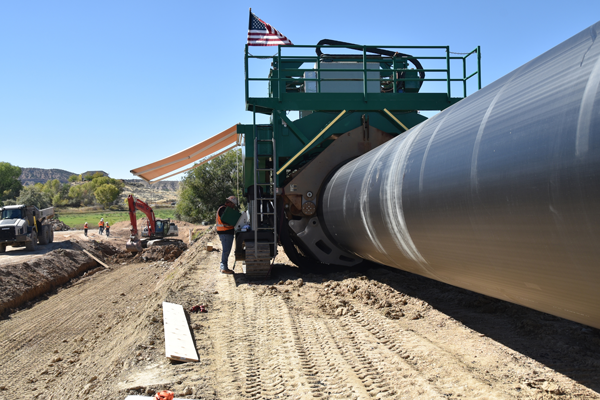 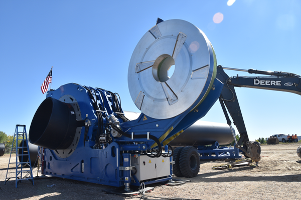 "They have already piped 3 miles of the canal," explained Strand. "This project will pipe almost 3 more miles. The entire canal is 12 miles long, so there will be 6 miles left un-piped. That portion will be piped in the future, based on the availability of funds. Eventually, the entire canal will be piped right up to Steinaker Dam and the outlet will be converted from a gravity flow pipe to a pressurized outlet so the entire pipe will be pressurized." What makes this project unique is the size of the pipe they are using to replace the canal. At 84 inches (7 feet) in diameter, the new Steinaker service pipeline is currently the largest diameter HDPE (high-density polyethylene) high-pressure water pipes in the nation. Each 53-foot-long section of pipe weighs 16,500 pounds and each section is trucked to the project site one at a time. The sections are then fused together on site using fusing machines specifically designed to work with HDPE pipes of that diameter or larger. With the completion of Reaches 2 and 3A, half of the service canal will be enclosed in pipe. This contract will be substantially complete in April 2023 with final completion scheduled for November 2023. |
 |
What lies beneath
|
|
from the |
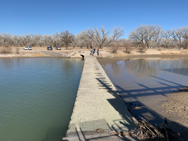 |
| Arizona Public Service Diversion Dam on the San Juan River. Reclamation photo |
Fish Passage at the Arizona Public Service Diversion DamBy Justyn Liff, Western Colorado Area Public AffairsThe Western Colorado Area Office is evaluating alternatives that would allow for fish passage at the Arizona Public Service (APS) Diversion Dam located near Farmington, New Mexico. The diversion dam was constructed in the 1960's to facilitate pumping water from the San Juan River to Morgan Lake. The lake is used as a source of cooling water for APS Four Corners Power Plant. Construction of dams and other features in rivers have reduced historical native fish habitat by altering the natural river flow and inhibiting upstream migration for spawning. Reclamation is a partner in the San Juan River Basin Recovery Implementation Program and the Upper Colorado River Endangered Fish Recovery Program. The Programs' goals are to recover endangered fish and conserve their habitats in the Upper Colorado River Basin while water use, and development continue. As a project partner, Reclamation's Western Colorado Area Office (WCAO) is in the feasibility stage of identifying alternatives that would retrofit the diversion dam and allow upstream migration of native fish, including the endangered Colorado pikeminnow and razorback sucker. As the WCAO researches possible fish passage alternatives, there are four primary goals:
The WCAO plans to have options available for public review and comment in summer of 2023. Additional information about the Recovery Programs can be found at: coloradoriverrecovery.org |
|
from the |
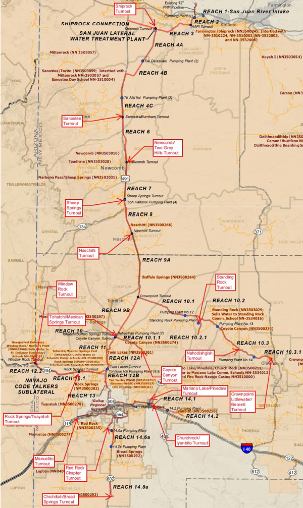 |
How communities will get water from the NGWSP PipelineBy Hubert Quintana, Four Corners Construction OfficeDo you ever wonder how the water will get from the pipeline to the communities and individual homes? The San Juan Lateral is shown in the picture above with the various "turnout" locations labeled. A "turnout" is the designated location in the main pipeline where each community's water distribution system will be connected to the NGWSP. The ten turnout locations shown also represent communities whose chapter leadership is working with the Navajo Nation to manage the pre-construction/construction projects which will connect each community into the NGWSP pipeline. As of August 2022, funds were granted to design the connection plans into the Sanostee, Newcomb/Two Grey Hills, Sheep Springs, Naschitti, Rock Springs/Tsayatoh, and Tohatchi/Mexican Springs communities, and data collection has begun. This was accomplished through a combined funding effort from the American Rescue Plan Act (ARPA-Federal Funds), the State of New Mexico (State Funds) and Navajo Tribal Funds. Beyond the initial connection into NGWSP, each chapter will continue working to obtain funds to develop their individual community plans, where having a reliable water supply available will allow for growth of new businesses and homes, as well as help those residents not currently connected to the existing NTUA water system. The NGWSP is being built to provide water from the San Juan River to replace the diminishing ground water supply across the Navajo Nation. Once built, the NGWSP pipeline will be connected into the existing Navajo Tribal Utility Authority (NTUA) water systems, allowing the existing ground water wells to be turned off in some cases, or at a minimum, be used less often, affording the groundwater aquifers to naturally recharge. NGWSP construction completion is scheduled for 2028 including the timing of the first surface water deliveries. Substantial completion is scheduled for 2029 after a year-long testing period. Reclamation continues to visit Chapter meetings to supply project updates in various communities during scheduled monthly meetings or by request. Please contact Becky Begay, the Navajo Outreach Coordinator for Reclamation out of the Four Corners Construction Office, with any requests to coordinate a visit with your Chapter about NGWSP. |
100th Anniversary of the Colorado River CompactThis November we will commemorate the 100th Anniversary of the signing of the Colorado River Compact. Stay tuned to social media and the Pipeline for our video series on the Colorado River Compact: The Framework for our Future to commemorate this significant centennial and learn more about how this foundational document became the basis for planning all of our future operations along the Colorado River. |

Interior Region 7 • Upper Colorado Basin 125 South State Street, Room 8100 Salt Lake City, Utah 84138-1147 If you would like to subscribe or unsubscribe to this newsletter, please send an email with your first and last name to ucbpao@usbr.gov. |
