 |
|
UC Today is the quarterly newsletter of the Bureau of Reclamation’s Upper Colorado Basin Region covering the states of Colorado, New Mexico, Utah and Wyoming. We look forward to sharing with you some of the projects and activities that we have been working on to manage, develop and protect water and related resources in an environmentally and economically sound manner in the interest of the American public. October 2021 |
|||||
| Upper Colorado Basin Region Office | Albuquerque Area Office Power Office | Provo Area Office | Western Colorado Area Office | Four Corners Construction Office |
|||||
|
from the |
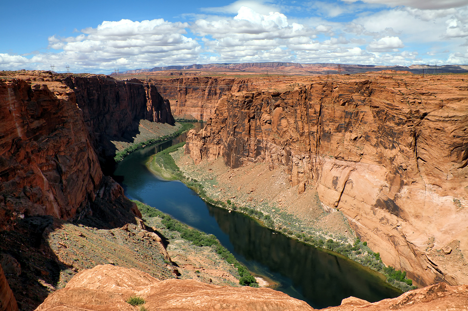 |
| Colorado River scenic view. Reclamation photo |
Reclamation releases updated projections of Colorado River system conditions
|
 |
The Colorado River Basin has a new Facebook page and we need you to help build our audience and followingYour Upper Colorado Region Public Affairs team has teamed up with the Lower Basin to manage a new Facebook page with content specifically geared toward the overall Colorado River Basin Region. The page is active now and will be promoted publicly beginning next week, Nov. 1. This page will continue to feature content that is relevant to the Colorado River Basin in an effort to better inform and educate the public about relevant information regarding drought, hydropower production, dam operations, hydrology, water releases, native species of the river, recreation in the basin, and the employees of Reclamation who help manage these resources. Please like and follow this new page and share with your friends and staff in the basin region. There are 40 million people who rely on the Colorado River, and we expect that thousands of them are on Facebook. We'd like to reach as many as we can! Have ideas for content or want to submit a photo? Great! Send to ucbpao@usbr.gov |
|
from the |
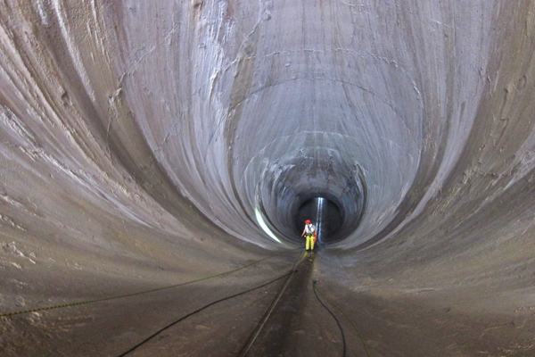 |
| Frederick Busch (BOR Civil Engineer at Western Colorado Area Office) rappelling into spillway tunnel to inspect and repair concrete. Reclamation photo taken August 2021 by Isaac Stephens |
Rope Access Team wraps up repairs at Flaming Gorge DamBy Emilia Ellison, Flaming Gorge Field DivisionWorkers at Flaming Gorge Dam recently completed a project that involved major cleaning and repair of concrete in the spillway tunnel. The bulk of the work took place Aug. 3-10, and was a cooperative effort involving the Upper Colorado Rope Access Team with members from the Power Office, Western Colorado Area Office, and the Central Utah Water Conservancy District. 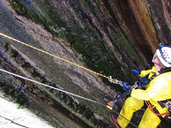 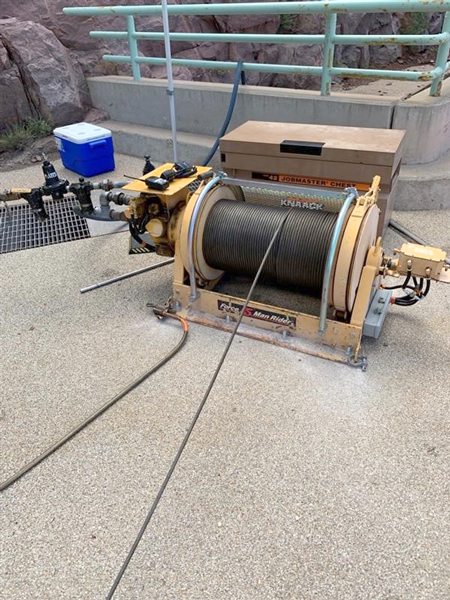 The team worked to remove and repair spalling and otherwise damaged concrete and cleaned calcite that had built up over many years and was several inches thick in some places. The water turbulence caused by spalling and calcite buildup in the tunnel can cause cavitation erosion which could lead to undesirable structural concrete damage. To complete this project, two to three members of the Rope Access Team rappelled down to various work positions on ropes while one person ran the "tugger." A tugger is a winch specifically designed for safely moving personnel and supplies using a wire cable instead of a rope. Generally, the workers descend on ropes and are brought back up individually by hooking onto the tugger which pulls them up much more quickly than using ropes alone. The team descended to the problem areas at various positions down the spillway tunnel, which narrows to approximately twenty feet in diameter and slopes at a fifty-five-degree angle. This effort was an exercise in operational safety while completing high-quality work that allowed for valuable cross-training. 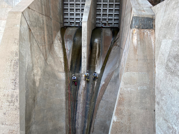 |
|
from the |
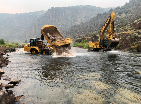 |
| Force Account operators use a dump truck and an excavator to place rocks in the riffle downriver of Linderman Diversion Dam. Reclamation photo |
The Adventures of Force Account: The Linderman Dam SolutionBy: Chris Watt, Public Affairs SpecialistAs Teton River rafters, canoers, and kayakers approached the Linderman Diversion Dam near Newdale, Idaho, they had to make a choice: take a chance and continue to row off the short drop over the dam in their boat, or row to shore and haul the raft, canoe, or kayak on land past the dam, and relaunch back into the river. 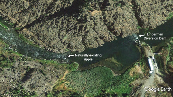 At Linderman Dam, the short drop, also called a low head drop, falls into a deep scour hole, a deceptively dangerous river condition where a submerged hydraulic jump is formed. A submerged hydraulic jump is like an underwater eddy that moves water back upriver in a recirculating undertow current that can be impossible to escape. The scour hole at the Linderman Dam below the low head drop was 30-feet deep. Then the Reclamation Upper Colorado Basin problem-solving team known as Force Account was handed the challenge to figure out how to keep the diversion dam operating while also creating a safer way for floating adventurers to pass by unharmed. The first thought by the team was to fill the 30-foot-deep scour hole below the weir with rock, gradually sloping the flow down to the tailwater elevation. This would eliminate the small waterfall while maintaining the required head of the diversion dam and provide a safe, navigable route for watercraft such as river rafts, canoes, and kayaks to pass over the dam without encountering the dangerous hydraulic jump. The challenge with this solution was trying to fill a 30-foot-deep scour hole with no practical way to temporarily divert flows during the construction. Through the value engineering process, alternative ideas were proposed. One of which was to evaluate a location downriver of the dam, where the water slows down and pools for about 100 meters before the river narrows and becomes gentle rapids, or a riffle, for some distance. If Force Account could somehow raise the water level of the pooling area, it would back up the river and inundate the weir portion of the dam, eliminating the dangerous low head drop of the dam. 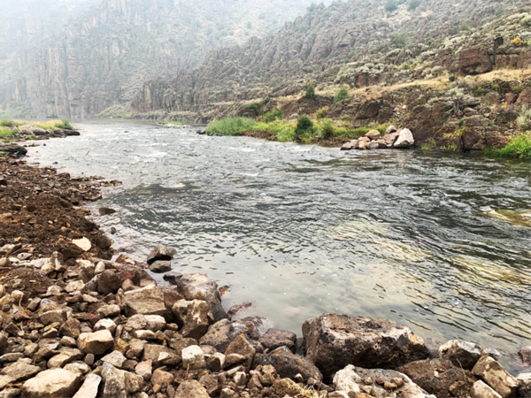 After evaluating the survey data and creating a new hydraulic model, it was determined that the natural riffle location downstream of the dam would be the ideal location to construct the artificial riffle to raise the water surface elevation of the entire upstream reach. The river was narrower there, it was easier for heavy equipment to approach, and the riffle was already made of shallower water running over many rocks and boulders, a feature that would later be used to make the project result look more natural. Because the river was more shallow at the riffle, the dump trucks and excavators could operate in the water without having to divert any part of the river first, saving a lot of time and minimizing any disturbance in the flow of the river. This was unintentionally aided by the historically dry water year and intentionally scheduled to be constructed during the river's lowest annual flow, during August and September. 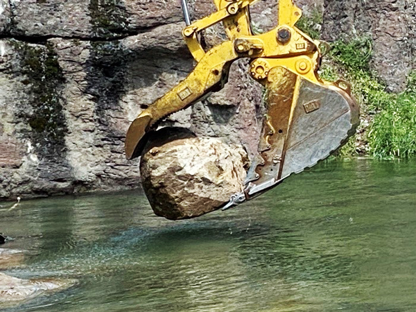 Using an excavator, the Force Account team placed each boulder in optimal, pre-designated locations to raise the elevation of water flowing from the upstream pool into the riffle. Because the team was placing the rocks on the bottom of the river while operating the excavator from above the water line, it would be understandable to expect the operators to struggle with being able to see what they were doing, requiring multiple, time-consuming grade checks by a surveyor. This excavator, however, was fitted with a GPS guidance system that could "see" what the operator could not under the water. Using the GPS-assisted controls, the team was able to load the design model into the onboard computer and construct the riffle with the aid of an onboard digital display, which showed the excavator's position and elevation in relation to the finished design surface. Checking grade was as simple as lowering the bucket to the ground and viewing the display. This allowed the operator to place the boulders in an offset pattern, locking them together through the structurally important crest of the riffle, taking most of the guess work out of the job, even though the operator's view from the windshield was obscured by the river water's surface and inevitable turbidity caused by the construction disturbance. 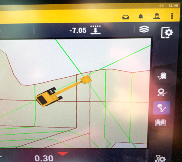 Once the larger rocks were properly placed in the riffle, smaller riprap, cobble, and gravel were dumped into the matrix of larger rocks to fill void spaces and densify the riffle, which further helped to push the flow up and over the riffle surface instead of flowing through the rock matrix. The process slowly raised the river elevation upstream of the riffle and past the dam, inundating the low head drop and eliminating the danger to recreators. The riffle performance will be evaluated for at least one full water year before Force Account will return to demolish the upper portion of the dam and return the river to a more natural looking state.  As a bonus, because of the location they chose, the work performed looks natural and, unless you were there and know where to look, the additional rock has blended into the river. The Force Account construction artists recognized and added to the patterns and aesthetic of what nature had already built, while also making the river safer for all to enjoy. |
|
from the |
 |
| Water flowing in the Florida Canal. Reclamation Photo by Kevin Moran |
Western Colorado Area Office updateBy Justyn Liff, Western Colorado Area Public AffairsConstruction Begins on Florida Canal Enlargement Lining ProjectConstruction began on the Florida Canal Enlargement Lining Project in Durango, Colorado Oct. 15. The project includes lining an open earthsection of the Florida Canal that meanders through the Meadows Subdivision, and eventually feeds into the Pastorious Reservoir. The project was a collaboration between Reclamation and the Florida Consolidated Ditch Company with input from Meadows Subdivision Homeowner's Association. By working together, the final design prioritized limiting disturbance of vegetation along the canal, and adjusting the alignment to avoid a large cottonwood tree that houses a redtail hawk. Designers also had to include factors such as tight right-of-way restrictions for staging areas and access points; a habitat study for the endangered New Mexico Jumping Mouse; and minimizing the amount of earthwork and materials needed, which proved to be an essential factor during award consideration due to the COVID-19 pandemic-induced material supply shortages and increases in cost. The canal lining will be a combination of polyvinyl chloride and geotextile lining, with a shotcrete cover that will mostly follow the alignment of the existing canal. This will reduce water conveyance losses, provide modernization of water deliveries, and reduce annual operation and maintenance costs. Primary features of the project include two new check structures, about 2.25 miles of lining, modified culvert transitions, removal of existing structures, an established operation and maintenance road, and seeding for disturbed areas of vegetation. 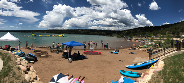 Lake Nighthorse Recreation AreaThis year was the fourth year that the Lake Nighthorse Recreation Area, part of the Animas-La Plata Project near Durango, Colorado, was open to public recreation. The recreation area is managed by the City of Durango and each year visitation numbers continue to trend upwards. In 2021, year to date visitation totals were over 100,000 for the first time. The recreation season began on April 12 and will continue until November 14. Recreational opportunities at Lake Nighthorse include shoreline and boat fishing; a swim beach; inflatable play structure; sailing and sailing lessons; boating; adaptive sports; water skiing and surfing; and paddle boarding. On September 11, a sprint triathlon was held requiring a 750-meter swim, 12.5-mile road bike ride, 3.1-mile run. The swim and running part of the event was held at the recreation area. The City of Durango has worked tirelessly to manage recreation at Lake Nighthorse. Reclamation looks forward to continued cooperation with the City of Durango to conserve and enhance Lake Nighthorse. |
|
from the |
 |
| 42-inch steel pipe installation - Block 4c-8. Reclamation photo by Hilda Castillo Smith |
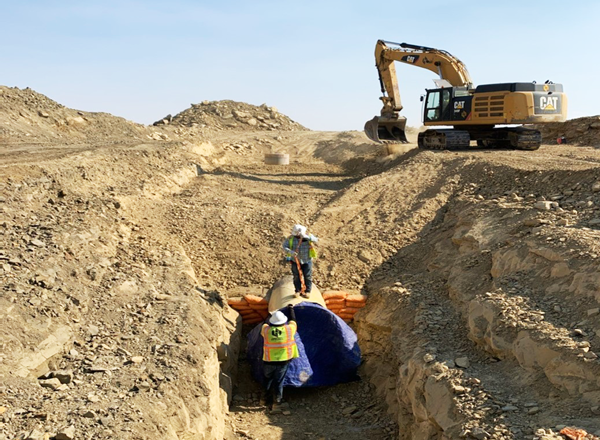
Navajo-Gallup construction moving forwardBy Patrick Page, Construction Engineer, & Hilda Castillo-Smith, Resident Civil EngineerSignificant progress continues on the construction of the Navajo-Gallup Water Supply Project. In this edition of the newsletter, we highlight the ongoing work by Reclamation and our partners on the Project. Reclamation currently has two active construction contracts. Block 4C-8 consists of the installation of 30 miles of 48-inch- and 42-inch-diameter steel pipe between Twin Lakes and Little Water, New Mexico. The contractor, Oscar Renda Contracting, Inc., began work in January 2020 and is scheduled to be completed in the spring 2022. 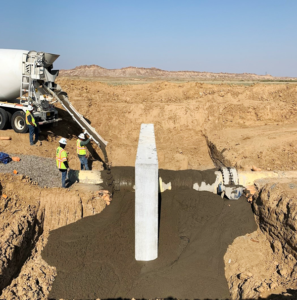 The second active contract is the construction of the Tooh Haltsooi Pumping Plant (Pumping Plant Number 4) near the community of Sheep Springs, New Mexico, and the Bahastl'ah Pumping Plant (Pumping Plant Number 7) near the communities of Twin Lakes and Coyote Canyon, New Mexico. Contractor Archer Western began construction on the plants in January 2021 and expects to complete the work in September 2023. The pumping plants are designed to lift drinking water through the transmission pipeline to higher elevations and communities south of each plant. Reclamation will also soon award a construction contract for the Navajo Code Talkers Sublateral that will supply water to communities along New Mexico State Highway 264 and the Window Rock/Ft. Defiance area. This construction will begin in early 2022. Reclamation's partners, including the Navajo Nation and the City of Gallup, are also busy constructing portions of the San Juan Lateral. |
|
from the |
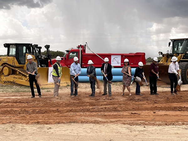 |
| AAO Deputy Area Manager, Jim Wilber, and Clovis and Portales city officials mark the occasion for Finished Water 3. Reclamation photo |
Groundbreaking marks next phase for rural water systemBy Melissa J. Romero, Writer-EditorAlbuquerque Area Office staff recently took part in a groundbreaking ceremony to highlight the latest project under the Eastern New Mexico Rural Water System. The Finished Water 3 kickoff event was held Aug. 12, hosted by the Eastern New Mexico Water Utility Authority, lead agency for construction. The occasion marks further progress on the ENMRWS with a 16.7-mile pipeline north of Portales, New Mexico. 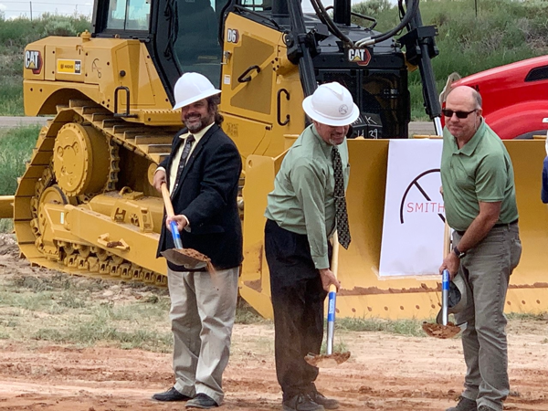 The project will occur in two phases. FW3A includes a nearly 12-mile portion of 20-inch transmission pipeline to be installed at the ENMRWS Main Junction Vault northwest of Cannon Air Force Base. The pipeline will continue south to NM State Road 467 and connect to the second phase, FW3B. Construction on the remaining five miles of FW3B is targeted to begin next year, pending final design and easement acquisition. Also known as the Ute Reservoir pipeline project, work on the rural water system has been steady along New Mexico's east-central high plains since early 2013. However, rather than follow a southward linear approach, construction priority is to connect all member communities which are currently at risk from the rapidly declining Ogallala Aquifer. The pipeline will initially provide a water supply from interim groundwater sources before the project moves north, eventually connecting the system to the reservoir.  Bureau of Reclamation obligated almost $15 million in additional funding in fiscal year 2021 to meet the full federal cost share for FW3. The additional funding also supports a recently awarded agreement for the planned Finished Water 1 phase, with construction expected to start in late summer 2022. The 15-mile pipeline of FW1 will connect both Finished Water 2, completed in 2020, and the new FW3 pipeline to a water treatment plant to be built near Grady, New Mexico. "The ENMRWS has made significant progress in the last five years, and the success of each project pulls together a long-term solution to meet eastern New Mexico's critical rural water needs." John Irizarry-Nazario, ENMRWS Project Manager The ENMWUA will own, operate and maintain the final water system that will serve the communities of Clovis, Elida, Portales and Texico, Roosevelt County and CAFB. Approximately 70,000 people region-wide will benefit from the ENMRWS, including 5,800 armed forces and civilian personnel stationed at the military base. |
Lees Ferry - 100 Years of Streamflow MonitoringOn October 1, 2021, the U.S. Geological Survey Colorado River streamflow gaging site (USGS 09380000) at Lees Ferry marked its 100-year anniversary of recording continuous streamflow data. As the gage of record for the apportionment of the Colorado River between the Upper and Lower Colorado River basins, the Lees Ferry site is arguably one of the most important streamflow sites in the U.S. |

Interior Region 7 • Upper Colorado Basin 125 South State Street, Room 8100 Salt Lake City, Utah 84138-1147 If you would like to subscribe or unsubscribe to this newsletter, please send an email with your first and last name to ucbpao@usbr.gov. |